Difference between revisions of "Drone Photography"
| (One intermediate revision by the same user not shown) | |||
| Line 5: | Line 5: | ||
With orthophotos taken using CIMS drones, you can be assured of a high-quality, spatially-accurate background image that can be used both in CIMS and Burial Search. | With orthophotos taken using CIMS drones, you can be assured of a high-quality, spatially-accurate background image that can be used both in CIMS and Burial Search. | ||
[https://www.cimscemeterysoftware.com/contact-us/ Contact our team] to learn more! | [https://www.cimscemeterysoftware.com/contact-us/ Contact our team] to learn more!<gallery widths="450" heights="300"> | ||
File:CIMS columbarium view using Google maps satellite imagery.png|Google maps satellite imagery will not be entirely accurate. Note how the columbaria, which the CIMS team mapped to their real-life latitude and longitudinal position, do not line up with the Google satellite images. | |||
File:CIMS columbarium view using drone imagery.png|With drone imagery taken by the CIMS team, the columbaria are now in their accurate spatial position. Other objects, such as headstones, chapels, trees and more, will also line up correctly with your map in CIMS. The image itself is also sharper and colors more realistic. | |||
</gallery> | |||
Latest revision as of 12:29, 1 November 2024
Using our drone, we can create high-resolution orthophotos that are spatially accurate and can be used in CIMS Gold and CIMS Platinum as your cemetery’s backdrop. We can also produce high-quality videos that can be used to market your cemetery and show off your beautiful grounds.
When using Google or Bing satellite imagery as your cemetery background, there are several disadvantages: When zooming in, images will appear blurry, especially in more rural areas. Also, these services will periodically update. While these images are roughly spatially accurate, they are not accurate to the degree CIMS drone imagery is, and your background images will noticeably shift. We are unable to control third-party satellite imagery.
With orthophotos taken using CIMS drones, you can be assured of a high-quality, spatially-accurate background image that can be used both in CIMS and Burial Search.
Contact our team to learn more!
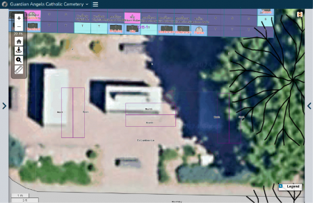
Google maps satellite imagery will not be entirely accurate. Note how the columbaria, which the CIMS team mapped to their real-life latitude and longitudinal position, do not line up with the Google satellite images.
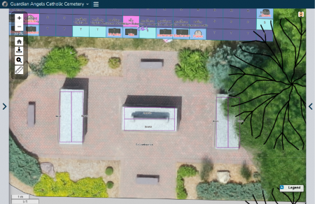
With drone imagery taken by the CIMS team, the columbaria are now in their accurate spatial position. Other objects, such as headstones, chapels, trees and more, will also line up correctly with your map in CIMS. The image itself is also sharper and colors more realistic.

